

 ROSEMARY IMOBHIO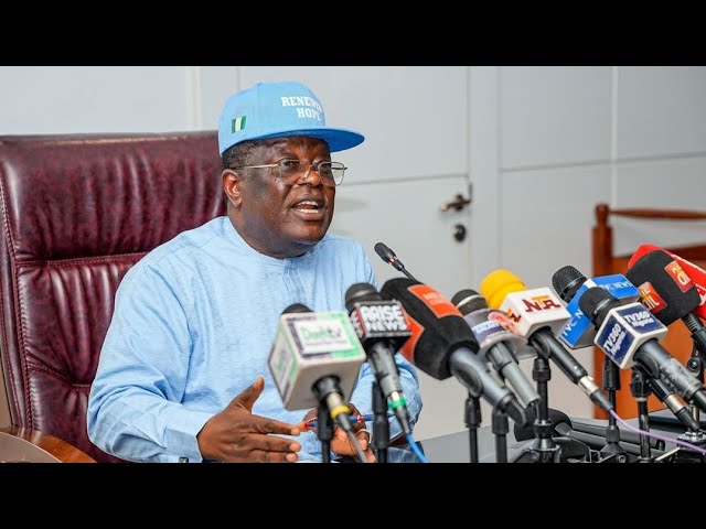
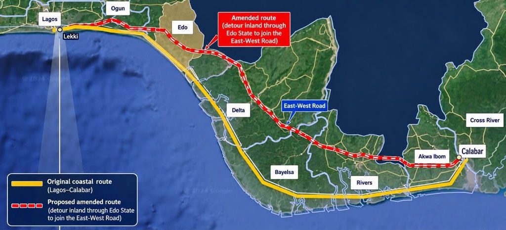
Nigeria’s Lagos-Calabar Coastal Highway is facing renewed scrutiny. This follows a community organisation in Ondo State calling for an independent investigation into the reported realignment of the project away from the Ilaje coastline. On October 11, 2026, Ilaje Omuro Community Connect (IOCC) urged the Federal Government, National Assembly and relevant anti-corruption agencies to examine the decision, its technical justification and its financial implications. The group also demanded the release of engineering studies, environmental assessments and cost estimates supporting the proposed route.
The dispute goes beyond where a major road should run. It raises questions about how infrastructure decisions are justified, how environmental risks are assessed and whether communities affected by public projects can access the information needed to understand them.
The Minister of Works, David Umahi, has defended the route change, citing difficult terrain, deep pits and higher construction costs along the original alignment. However, affected communities want the technical evidence behind that explanation made public. The disagreement therefore presents an important test of transparency. Can the government demonstrate that its decisions balance engineering feasibility, environmental protection, public expenditure and community interests?
What Evidence Supports the Highway’s Environmental Decisions?
The route controversy follows earlier questions about the environmental assessment process for the highway. During a media engagement, an ARISE News journalist questioned Umahi about the Environmental Impact Assessment (EIA) for the project. The exchange attracted attention after the minister responded dismissively to the journalist’s accent. Nevertheless, the more consequential issue remains whether the public can examine the environmental evidence informing the highway’s construction and design.
The Federal Ministry of Environment’s Environmental Assessment Department published draft Environmental and Social Impact Assessment (ESIA) reports for the first two sections of the highway. The Section 1 report, covering approximately 47.5 kilometres, was placed on public display on August 27, 2024. A draft assessment for Section 2, covering kilometres 47.5 to 104, followed on October 13, 2024. Both notices provided for 21 working days of public display and comments.
These records establish that draft assessments were publicly displayed for the two sections. However, the notices alone do not establish the complete approval history. Or whether every required step preceded construction or what assessments informed subsequent route changes.
Questions also remain about the availability of corresponding assessments for Sections 4A and 4B, associated with the Ogun and Ondo corridors. The absence of a readily identifiable public report does not prove that no assessment exists. Nevertheless, the relevant authorities should clarify whether these assessments have been prepared, submitted, approved and disclosed.
For a project extending across several coastal states, transparency should not depend on citizens having to piece together the environmental record from separate announcements, interviews and incomplete disclosures.
What Could the Environmental Impact Be?
Environmental risks must be established through evidence rather than political disagreement. However, the highway’s location makes careful assessment particularly important.
Depending on the alignment and construction methods, activities such as dredging, land reclamation, excavation and embankment construction can affect drainage, water quality, coastal processes and sensitive habitats. In wetland and coastal environments, changes to water movement can also affect ecosystems beyond the immediate construction footprint.
These possibilities do not establish that the highway has caused particular flooding incidents or ecological damage. Indeed, such conclusions require monitoring data, technical investigations and comparisons with existing environmental conditions.
On October 4, 2026, Umahi dismissed concerns that the highway was contributing to flooding in Lagos. He argued that flooding along the corridor predated the project and maintained that the road had been designed above the relevant flood level.
His explanation places greater importance on the evidence behind the design. What flood projections and drainage studies informed the road’s elevation? How have engineers assessed water movement around adjoining communities? What monitoring has been undertaken to determine whether the project is affecting surrounding environments?
Publishing relevant studies and monitoring results would allow independent experts to evaluate these claims rather than leaving the public to choose between competing assertions.
Why Route Changes Need Environmental Scrutiny
The Ondo dispute also demonstrates why environmental assessments must remain relevant as projects evolve. A route change can be justified by geological conditions, construction costs, safety or environmental considerations. However, an alternative alignment can also create different risks, affect different communities and change the distribution of economic benefits.
IOCC has argued that bypassing the Ilaje coastline could constrain opportunities in fisheries, agriculture, tourism, trade and logistics. The group also cited existing challenges in the area, including coastal erosion, seawater incursion and inadequate transport infrastructure. These concerns require examination, particularly because communities already experiencing environmental pressures may have limited capacity to absorb further disruption.
Consequently, the government should publish the comparative engineering and environmental assessments behind the proposed alignment. These should explain the alternatives considered, their estimated costs, their anticipated environmental effects and the expected benefits for affected communities.
Importantly, assessments should consider cumulative impacts alongside the effects of individual construction sections. A project divided into separate contracts can still interact with wider coastal ecosystems, drainage networks and existing developments.
International frameworks, including the International Finance Corporation’s Performance Standard 1, emphasise the assessment and management of environmental and social risks throughout a project’s life cycle. The precise obligations depend on the applicable financing and regulatory arrangements, but the underlying principle remains relevant: identifying risks is only useful when the findings inform decisions and mitigation measures.
Read: Implications of Coastal Road Land Sale on Sustainable Development in Nigeria
Who Is Accountable for the Answers?
Nigeria’s Environmental Impact Assessment Act provides a legal framework for assessing the environmental consequences of major development projects. The Federal Ministry of Environment’s public-display process also provides an opportunity for stakeholders to submit comments before decisions are made.
However, public participation becomes meaningful only when people can access relevant documents early enough to understand the proposals and raise informed concerns. Publishing a draft report is one step. Explaining how submissions were considered, disclosing the resulting decisions, and demonstrating compliance with required safeguards are equally important.
For the coastal highway, the Federal Ministry of Works and environmental authorities should clarify the approval status of the relevant sections, including the assessments supporting revised alignments. They should also explain how communities can raise concerns, what monitoring arrangements are in place, and how identified environmental harm would be addressed.
An independent technical review of the Ondo realignment could help resolve competing claims about its feasibility, environmental implications and cost. Any review should assess the evidence fairly rather than presume that the route change is either improper or justified.
Furthermore, the findings should be made public. Transparency would enable citizens to understand the basis of the decision while allowing the government to demonstrate the merits of its chosen approach.
Can Infrastructure Be Sustainable Without Transparency?
The Lagos-Calabar Coastal Highway illustrates a broader challenge for sustainable development in Nigeria. Major infrastructure can improve connectivity, create economic opportunities and support trade. However, those benefits must be considered alongside environmental risks, public expenditure and the interests of affected communities.
A road’s length, construction progress or engineering specifications cannot, on their own, establish its sustainability. That judgement also depends on how risks were assessed, whether safeguards are effective and whether decision-makers can account for the consequences.
The current controversy does not, by itself, prove that environmental rules have been breached or that the proposed route is technically unsound. It does, however, make a compelling case for clearer public disclosure and independently verifiable explanations.
Ultimately, the government should not have to choose between building infrastructure efficiently and being transparent about its decisions. Both are essential to public confidence.
As Nigeria continues to invest in major infrastructure, the question is not simply whether the coastal highway will be completed. It is whether the environmental evidence, community safeguards and accountability mechanisms behind it will stand up to scrutiny.
| DON’T JUST ANNOUNCE YOUR IMPACT. PROVE IT. CSR REPORTERS helps organisations verify, assess, document and communicate the real impact of their CSR and sustainability initiatives. Project Verification | Beneficiary Feedback | Impact Assessment | Impact Storytelling | Stakeholder Engagement Have an initiative worth documenting? Let us verify it. Document it. Tell the story. Talk to CSR REPORTERS enquiries@csrreporters.com 📞 Call/WhatsApp: 0803 401 2198 | 0903 329 6374 | 0905 024 4468 | 0803 209 8499 www.csrreporters.com |